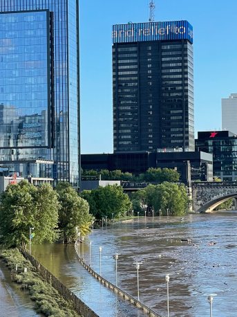
Philadelphia’s trails took a beating from Hurricane Ida, and some will take months to recover. Two weeks after the floodwaters receded, we look at conditions along the Schuylkill River Trail with representatives from the City of Philadelphia and the Schuylkill River Greenways National Heritage Area.
Hurricane Ida slammed into Greater Philadelphia on September 2, causing at least five local deaths and untold millions of dollars in property damage. Ida also took a heavy toll on the popular Schuylkill River Trail, which, when completed, will extend 126 miles upstream from the heart of Center City into Schuylkill County.
The impact was staggering, but Philadelphians rallied behind the cleanup effort. After the storm, WPVI-TV reported, volunteers made short work of lingering mud and debris along the SRT at Schuylkill Banks under the direction of staff from the Schuylkill River Development Corporation, which manages the property.
There’s a lot of muck and mud next to the Towpath. People may think they can walk on it, but next thing they know they’re sinking.
Schuylkill Banks is looking much better today, but other parts of the SRT haven’t fared as well. Some sections still haven’t completely reopened and officials say it will take months to fully recover. Two weeks after the storm, the Manayunk Canal Towpath section remains closed, and isn’t expected to reopen until October.
“All of the river muck and sediment and mud was washed up on a trail that is essentially a stone fines or cinders trail, which is a lot harder to clear than a paved trail,” said Rob Armstrong, Program Manager with the City’s Office of Transportation and Infrastructure (OTIS). “You had the muck, and then you also had downed trees… washouts and the like.”

The storm also took out a section of protective fencing between the trail and the river, Armstrong said, creating a further safety hazard. Officials stress that people should avoid closed trail sections to let cleanup crews work, but also for their own safety.
“We don’t want people going onto the Canal Towpath even if they think it’s passable, because there’s a lot of muck and mud next to the canal, next to the towpath. People may think they can walk on it, but next thing they know they’re sinking.”
The rest of the SRT within Philadelphia is open and passable to varying degrees, though cyclists may need to dismount and go around some rough patches.
Further upstream, damage was spotty and less severe, but serious enough to briefly shut down sections of the SRT directly managed by the Schuylkill River Greenways National Heritage Area (SRG).
“There’s a section up outside of Hamburg that basically got washed out,” said SRG Executive Director Elaine Schaefer. Elsewhere, a “huge logjam” has accumulated under an SRG-owned trail bridge. “That’s going to cost a very pretty penny to remove,” she said.
The trail surface itself is passable, Schaefer said, “but it’s not perfectly clean.”
It’s not a one-size-fits all response for our trails.
Flooding from smaller waterways also managed to affect other Philly-area trails, including those maintained by Wissahickon Trails, whose offices along the Wissahickon Creek were badly damaged.
“The storm wiped out over a mile of our trails,” said Chris Mendel, Executive Director of the Pennypack Ecological Restoration Trust. The trails that parallel the Pennypack Creek, including the Creek Road Trail and the Pennypack Creek Trail, were hit especially hard.
“In effect we’ve lost our main artery trail,” said Mendel.
Luckily, some of their trails held up “remarkably well,” according to Mendel. He explained that the trail design included a set of fiber-reinforced pockets filled with ballast stone and covered with a finer crushed stone, which created a permeable surface that water can pass through instead of pooling.

Of course, one trail design won’t work for every situation. Mendel’s best advice for designing trails that will be able to withstand increasingly common severe storms is to have a variety of potential strategies.
“The key is variability, knowing that you’re building out a recipe book for how to respond to more intense storms in specific locations,” said Mendel. “It’s not a one-size-fits all response for our trails.”

